
Our route included:
Pretoria, Pafuri, Mapai, Maxaila, Chigubo, Tesenane, Funhalouro, Massinga, Morrungulo
Trip to Mozambique, July 2004


Our route included:
Pretoria, Pafuri, Mapai, Maxaila, Chigubo, Tesenane, Funhalouro,
Massinga, Morrungulo
The idea to publish this page came about because, while
planning this trip, we couldn't find any useful information on previous
attempts. Our research included:
www.gpswaypoints.co.za for GPS waypoints and maps and The Department
of Water affairs for the water level of the Limpopo. We also chose to
travel in winter because during the dry season the river levels are
normally lower.
 We
left Pretoria at around
22h00 on
the 28-Jun-2004. Our first destination was the Punda Maria gate into
the Kruger
Park. This part of the trip was uneventful with
some light
rain on the way. We arrived at the gate just before opening time and
after paying the day visitors’ fees, we topped up with fuel for the
last time. The next stint would take us to the Pafuri border post. The
light rain
kept falling and after about one hour, we arrived at the post without
having seen much game. The
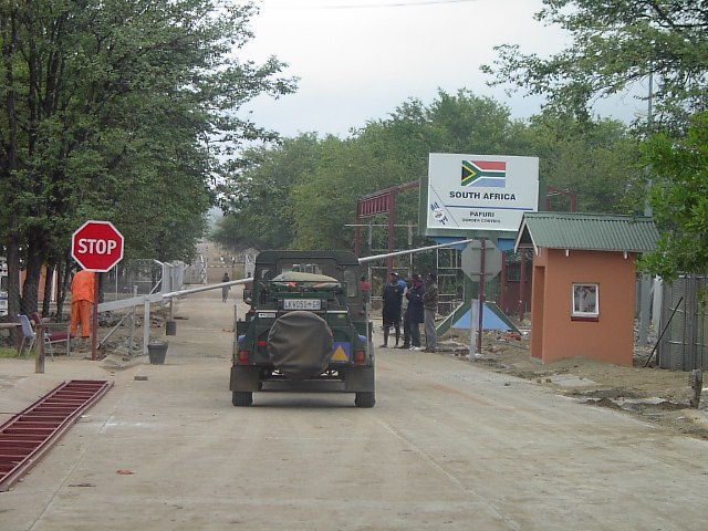
border formalities were painless and after having the engine numbers
checked, we crossed to the Mozambican side.

The
adventure starts here! It was about 9h00 of the 29-Jun-2004. We
were the only travelers at the post, which made it quick and simple.
The
post seems to be manned by two individuals, the immigration official
and an armed man. The customs building is in ruins and they have no
forms to fill in. Therefore, we skipped the
usual customs formalities.
 The next
leg took us to the Limpopo
crossing near Mapai. These
80Kms take about 3h30 to
cover with many photo opportunities on the way. The road/track follows
the Limpopo South and the type of surface varies. Some times very rocky
and others, when next to the flood plain, sandy and bumpy. Worth
mention are the
many baobab trees right next to the road. About 5km from the river
crossing we encountered a Mission and across the road they are
building a school for the local children. The Mission is a good land
mark because a few hundred meters further we turned left to the river
bank.
 Before
our departure from South Africa, we had checked with the Department of
Water Affairs for the rain forecast and river level. But upon arrival
at
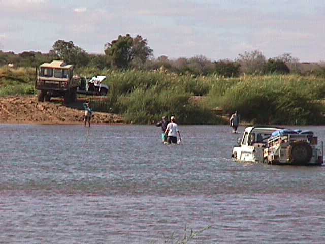
the river crossing, we were surprised by the width of the Limpopo and
the amount of water it was carrying. The Limpopo was at least 150m
wide and in some places the current made it difficult to walk across.
Those conditions had already claimed some victims. A 4x4 bus was stuck
on the island and a Samil, a kind of a Unimog, got stuck trying the
recover it.

We surveyed the river bed on foot for hours but, with
off road trailers in tow, we couldn't find a safe place to cross it.
Eventually the fatigue was setting in and with the sun going down
fast; we decided to set camp overnight. A few km' back there
is the Mission and for the sake of safety, we asked them if we
could set camp there. The missionaries were very friendly and
welcomed us to stay next to their vegetable garden. They are doing a
great job helping the aids orphans.
 At
this point we were considering to follow the Limpopo
down to Xai-Xai, but this would mean adding hundreds of km' to our
trip, missing precious days on the beach and defeat.
After a night’s rest, we decided to attempt the crossing. It
was then the 30-Jun-2004 and at 7h00 we headed to the river bank.
There we found a new victim. At about 17h00 of the previous day, he
attempted the crossing and got bogged down. With no help in sight, the
car
stayed in the river and the wet passengers on the river
bank. He was stuck on the best crossing place and we decided to help
him.

After a couple hours of hard work, we got him out and were
ready for our attempt. The TDI went first but, after it had done
about 2/3 of the crossing, the trailer decided to become an “anchor”
and the Landy had the four wheels spinning. On the other bank, the
driver of the Samil offered to help. With his winch cable fully
extended, plus the Landy's own cable, it was still about 30m short.
Fortunately there was an extra length of cable to make up the
difference and the Landy was freed.
 I was next! Aware of all the
possible difficulties and concerned that
the TD5's computer box could give problems if it got bogged down for an
extend period, I decide to enlist the local help. The way the
locals get their cars across is quite simple and efficient. So I
decided that my 1 tone trailer would go first. With no trailer in tow,
my Landy made the crossing with extreme ease.

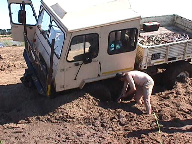
We were far from being on our way across Mozambique! The
Samil which had helped the TDI got bogged down in the slippery clay.
Another group of several 4x4s and a Samil were also making the crossing
and got stuck too. It was mayhem! Now our two Land Rovers were the
recovery vehicles. After we got one Samil out of the river and the
other off the mud, we were ready to get on the way.
 It was around 13h00 of the 30-Jun-2004 when we finally left
the river banks. We were a day down on our schedule and decided to
drive through to our destination. This was easy said than done, because
we still had more than 500Km of off road to cover and most of the trip
would be done at night (not as originally planned! ). But we were
feeling confident, we had our
route plotted from a very detailed map, the co-ordinates loaded into
the
GPS and the beach was calling us!
 The map is very detailed indeed, it's an old map downloaded
from the
CIA web site, but it didn't show the landmined roads! And as it can be
seen from our GPS track, the blue dots on
the map, we had to avoid some mapped
roads. We reached Maxaila still with day light, this was the furtherest
northern point of our trip. But before we could get to the flood plain
of
the Aluize river, night had set in. The road then took a sharp right
turn and completely by passed the mapped one, probably due to landmines
too.

We arrived at Chigubo at around 20h00 in complete darkness, has
there's no electricity there. In conversation with the locals, we found
that we shouldn't follow our planned itinerary because the road had
landmines. They advised us on a new road, I mean a new track, which
was safer. This took us to a lake before Dolela and to a dead end on
the track. We were kind of lost in the middle of nowhere! The main
road
had landmines, this optional one came to a dead end, we had been on
the road since 7h00 and it was about midnight.
 After some looking
around, we found a local fisherman which explained to us that the road
indeed ended there. He tried to tell us how to get back on track, but
we decided to bring him along to show us the way out. Once we knew how
to continue, we drove him back and resumed our trip. We drove for what
felt like hundreds of Km, but it wasn't much more the 50km. The road
was an endless zig-zag and we couldn't go faster than 20km/h. When we
got to Tesenane, the track became a wide gravel road for about
50km, which
brought us to the next main town, Funhalouro.

From there were just
another 120km and because it was a main town, we were expecting an
improvement on the road. Well, it couldn't have gotten any worst! The
road was, some time ago, heavily landmined and as a result there are
more potholes than road. Eventually I couldn't drive any more! I was
too tired and couldn't keep my eyes opened, that's when my wife
took over and drove the last 60km. We arrived at the beach at about
7h00 on the 1-Jul-2004, which was 24 hours after we had crossed the
Limpopo. It had been a challenging 24 hours of off road driving, but
finally we were at the beach! We could have taken an easier route or
even the tarred road, but
we took the historical route. We went through the places where the
biggest battle
of the Rhodesian war was fought and when the intention is adventure, nothing is too tough!
 P.S. Attention Jap-Crap lovers,
the Landys didn't even get a flat tyre!
 We set camp and for the first
couple of days the weather was
perfect, but then the rain came and spoiled the holiday. Because we
couldn't work on our sun tan, we decided to make some short trips
around the area. We visited a lake, went to Massinga ,shopping, and
called home and
hunted for a trig beacon. This was quite fun because we had the
approximate co-ordinates but had to make our own tracks to find it.
Making our own tracks caused some battle scrars. The TDI bent the
passenger's step and the TD5 got the roof re-shapped by a Caju tree
branch. Eventually the sun came out to let us enjoy the last day. The
trip back
was via the EN1, with a stop at Maputo before the final leg to
Pretoria. At the South African border they made us throw away any
animal products that weren't vacuum packed, which makes me wonder, what
would have happened if we had brought ALL the fish we caught.
Some of our holiday pictures.
Pictures of a previous trip
to Morrungulo, but on this one we used the tarred road.
Link to our trip to
the Central Kalahari and some other fun days.